


Chennai, Dec 12: Heavy rains accompanied by high- velocity winds pounded the city and coastal districts of north Tamil Nadu as severe cyclonic storm "Vardah" commenced its landfall through the coast, killing two persons and forcing the evacuation of thousands of people from low-lying areas.
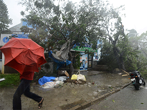
The cyclone, that triggered strong winds of nearly 100 km/h, uprooted hundreds of trees and disrupted power supply lines besides land and air transport, throwing normal life out of gear. "The cyclone is still crossing, only the eye portion has crossed... Presently it is calm. The entire system is expected to fully cross coast between 6 PM and 7 PM," a top India Meteorological Department (IMD) official told PTI here.
Showers and heavy winds will resume once the eastern portion of the system begins to blow over, the official said. However, the respite is Vardah is "weakening" and is expected to be turn into a "cyclonic storm" in next three hours, said M Mohapatra, IMD Additional Director General (Services).
"The Cyclone made its landfall near Chennai between 2:30 PM to 4:30 PM bringing in winds clocking 11-120 kmph. It is showing signs of weakening and the wind speed will reduce to 60-70 kmph in next 3-4 hours," he said.
Tamil Nadu Chief Minister O Panneerselvam urged people in Chennai, Tiruvallur and Kancheepuram districts - where "Vardah" brought life to a virtual halt - not to venture out of their homes till an official announcement was made.
Two persons had died and 24 huts were damaged, most of them in Tiruvallur district, according to an official statement.
About 8,000 people from low-lying areas in north Chennai, Pazhaverkadu in Tiruvallur district and villages off Mamallapuram, in Kanchipuram district were safely evacuated to 95 relief shelters, officials said.
Authorities here were seen swiftly removing uprooted trees and restoring snapped power lines, trying to bring normalcy to enable vehicular traffic to resume.
The IMD's latest inputs indicated that heavy wind and rains would continue till about 7 PM, Panneerselvam said, adding all arrangements are in place to handle the situation.
Coastal regions of northern Tamil Nadu - Chennai, Tiruvallur and Kanchipuram - continue to be on high alert even as people in low-lying areas were accommodated in relief centres.
Fishermen from Adyar and Tiruvanmiyur areas were accommodated in local schools and food and blankets were being distributed to them. State Ministers are visiting relief centres and inspecting distribution of food to the people, an official release said.
Under the impact of "Vardah", hundreds of trees were uprooted, land and air transport was disrupted and normal life was thrown out of gear in many areas.
Power supply was suspended in many areas. Long distance buses were stalled and traffic came to a grinding halt in most areas.
All suburban train services were also suspended by Southern Railway. Trains to various destinations, including Bangalore, Hyderabad, Madurai, Coimbaore were all cancelled, Southern Railway said.
Over 15 teams of NDRF have been deployed in various coastal regions of Tamil Nadu and Andhra Pradesh, where over 9,400 people living along the Bay of Bengal coast were evacuated to relief camps amid heavy rains.
IMD Director-General K G Ramesh said: "Strong winds of 92km/h have been recorded. Chennai has been experiencing heavy rains since morning and heavy rainfall zone is persisting over west of Chennai and south of Chennai. This would continue for couple of hours more. "...strong winds are there for northern parts of Chennai up to Nellore district of Andhra Pradesh."
He said power transmission lines and cables on the poles have got damaged due to which traffic-related interruption will be there in the city and suburban areas also wherever heavy rainfall is taking place.
"Once the complete landfall takes place, dusty winds will then slowly recede over to coastlines by the night or middle of night and rainfall will continue in interior parts of Chennai, and definitely intensity will reduce over Chennai by midnight," he added.
Responding to a question, Ramesh said strong surge will be to the north of the landfall point. "It is about the astronomical tide... Because of the full moon high tide is already there and so over and above, 1 metre surge is expected."
When asked how severe was the cyclone compared to Phailin, which hit Odisha in 2013, he said "Vardah" is a "severe cyclonic storm" while Phailin was an "extremely severe cyclonic storm".
"It will take six more hours for the storm to turn into a cyclonic storm," Ramesh said.
Under the cyclone's influence, rains at most places with "heavy to very heavy" falls at few places very likely to continue in Chennai, Thiruvallur and Kanchipuram districts of north Tamil Nadu, Puducherry and Nellore district of Andhra Pradesh during next 12 hours after landfall.
As the cyclone moves inland, north interior districts of Tamil Nadu and Rayalaseema may also experience "heavy to very heavy rain" at isolated places during next 24 hours after landfall and squally winds reaching 40-50 kmph gusting to 60 kmph are likely during 12 hours after the landfall.
The state government said 37 fallen electricity poles were removed in affected areas of the state. A total of 224 roads were blocked, of which 89 were cleared and 190 of 226 fallen trees removed. It said 266 relief centres are ready of which 95 are operational.
A total of 10,754 food packets were distributed to people in low-lying areas, now sheltered in relief centres.


Comments
Add new comment